Design and construction technology focused on securing structural stability by analyzing the dynamic changes of soil layers and bedrock properties.
-
- NATM Tunnel Design and Construction Technology
- Expertise in planning, designing, constructing, and maintaining structures, foundations and tunnels, as well as in disaster prevention measures, is crucial for large cross-section underground spaces and long tunnels spanning several kilometers. Our capabilities encompass geological survey result analysis, cross-section planning, excavation method selection, and ensuring safety, durability, and cost-effectiveness through numerical analysis reviews.
-

Large cross-section and deep tunnel planning
-
- Cut and Cover (C&C) Temporary Earthwork Retaining Wall Stability Analysis Technology
- By implementing actual stage-by-stage excavation plans in 3D numerical analysis for temporary earthwork excavation during urban underground road and subway construction, we account for varying excavation depths per section. This allows us to predict possible ground displacements and retaining wall member forces, which helps with design VE or construction risk identification and response planning, as seen in projects like the Singapore MRT.
-

Stage-by-stage review through 3D FEM analysis
-
- TBM Tunnel Design and Construction Technology
- Tunnel boring machine (TBM) tunneling involves mechanized and automated construction processes, from tunnel excavation to structural work and the removal of excavated rock and soil. This safe and eco-friendly method effectively excavates underground spaces, and our technical capabilities span all phases from planning, equipment selection, construction management, and risk hedging to construction.
Shield TBM tunnel construction
-
- Soft Ground Design and Construction Technology
- We have developed displacement reduction, elastic lotus, and large cross-section deep cement mixing (DCM) methods to improve the construction period, cost, and quality of ground improvement techniques, which are being applied to overseas sites, such as Hong Kong and Singapore, as well as Korean sites.
DCM technology development and site application
-
- 3D Precision Stratum Visualization Technology
- To elucidate geotechnical risks in overseas projects and proactively prevent technical accidents, we employ cutting-edge geophysical exploration methods, such as elastic wave exploration, electrical resistivity exploration, and ground-penetrating radar exploration, to accurately visualize stratum structures. Our expertise spans various scales, from shallow foundation architecture/civil engineering structures and tunnel-front investigations to deep-ground resource and earthquake surveys.
-

Geophysical exploration techniques for ground investigations
-
- Underground Facilities Exploration and Ground Subsidence Risk Assessment Technology
- We possess a range of technologies for non-destructive ground investigation and evaluation, using the physical properties of shallow ground to proactively identify and address underground facility and ground subsidence risks, such as sinkholes.
-

Underground facility and non-destructive testing technologies
-
- Slope Stability Analysis, Design and Evaluation Technology
- Our technical capabilities allow us to select the optimal slope method based on slope characteristics (topographic and geological analysis, slope scale) and project requirements. We can determine the most suitable reinforcement quantity through stability reviews of applied slope methods, and establish reinforcement and maintenance strategies.
-

Slope face mapping and stability analysis
-
- Geotechnical Information Digital Database and 3D Visualization Technology
-
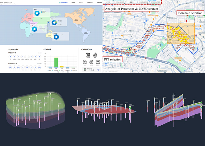
In order to improve the digitalization and utilization convenience of the ground information DB, which is the basis of construction work, we have developed a digital map-based ground information system (DGIS) that can accumulate, analyze, and inquire ground information, and are using it in practice.
It is used to calculate the amount of civil engineering work and plan excavation construction through the connection of 2D/3D stratum information and Building Information Modeling (BIM), and contributes to resolving the ground risk when bidding / performing through 3D image analysis of stratum information.
-

3D image analysis of stratum information


